Did anyone get blown away yesterday? Are all pets accounted for? It’s been a rough week in terms of wind and other weather events. We had sustained winds in the upper 30’s with gusts up to 46 miles per hour (freedom units) in our neck of the woods. This begs the question, why can it get so windy?
Bonus Fun Fact: Wind is caused by the movement of air from a high pressure atmospheric region to a low pressure region and the speed of that wind is greatly influenced by how close those air masses are to each other.
What does that even mean? Let me try to break down the process.
Solar radiation (sunlight) heats the earth’s crust and the nearby air. The warmed air rises, creating a low pressure region that pulls in surrounding, cooler air. At the same time, air that climbs high in the atmosphere is cooled. The cooled air descends back into other areas, creating high pressure regions. It’s all very complicated and we’re oversimplifying here. I’m a biologist, not a meteorologist! Anyway, the warming and cooling isn’t uniform and is influenced by lots of factors. Things such as altitude, slope, cloud cover, and jet streams all play a role. Also, it’s happening on a very large scale. High and low pressure regions can be the size of whole or multiple states!
So, you have state-sized masses of high and low pressure air, all smooshed together across the landscape. This is where wind comes into play.
The air in the high pressure region wants to move to the region of low pressure. This is what causes wind. Think of it like this, if you let air out of a tire (high pressure) it will rush out into the atmosphere (low pressure). It’s basically the same thing except way bigger and much more complex. The atmospheric air from the high pressure region rushes into the low pressure region. Gas always seeks a state of constant pressure across its volume (equilibrium). The air in our tire will stop flowing out when the pressure inside the tire equals the pressure of the outside atmosphere. Atmospheric air masses do the same thing, but there is no finite container to equalize between — the air constantly cycles around the planet.
Now, the strength of the wind has to do with how closely these high and low pressure air regions are to each other. The closer they are, the more severe the pressure gradient is between the two. That is to say, the pressure changes more quickly when travelling from one pressure region to the other. If they were far apart, the change in pressure would be more subtle. With differing air masses close together, the air moves more quickly, causing higher winds.
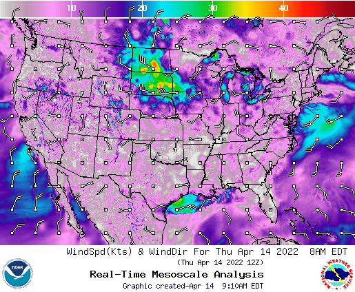
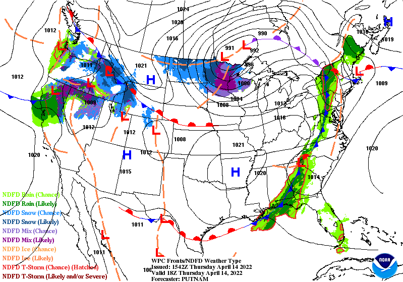
On days like yesterday, where we had 30-some mile per hour winds, differing pressure air masses in the Midwest were quite close together, relatively speaking. There was a high pressure airmass centered over the Wyoming-Montana state border and another, low pressure, airmass over northern Minnesota. The area between the two, including us here in southwest Iowa, experienced exceptionally high westerly winds because of it.
Next time your hat blows off in the wind, you’ll know the reason why!

Leave a comment