I received a few comments about how I didn’t do a bonus fun fact last week. Well, that’s because I was teleworking this week (and next week too). I didn’t think it was necessary to put together an email with my office schedule and, by extension, a bonus fun fact. I was clearly mistaken and I apologize for that.
With severe weather season quickly approaching, I wanted to share a few things that I very recently learned about thunderstorms:
Bonus Fun Fact: Shelf clouds come at the leading edge of storms and wall clouds (where tornadoes form) appear at the rear.
Shelf clouds are wedge-shaped, horizontal formations at the base of the storm. They mark the leading edge of the storm front and, when they pass by, the temperature generally drops noticeably and winds can increase significantly. Below is a picture of a shelf cloud.
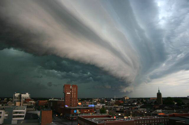
I always thought that these were wall clouds. Doesn’t it look like a wall? Like many other times in my life, I have found out I am wrong. Anyway, it’s a shelf cloud, not a wall cloud. They look super scary, but are not dangerous in and of themselves. They can even rotate horizontally, which really looks scary, but even that isn’t dangerous.
Speaking of scary, dangerous, and rotating, that brings us to wall clouds. A wall cloud is a narrow projection of the cloud base between the rainy downdraft side of the storm and the rain-free updraft on the other side. This is where all the warm, humid air is being sucked up into the storm. Because of this air sucking, wall clouds can rotate vertically (but not all of them do). This vertical rotation is what can form tornadoes. Not all wall clouds can or will produce tornadoes, but they are a sign of significant updrafts in the storm.

In the picture of the wall cloud above, look how it’s dark and raining on one side, and clear and light on the other. That’s not coincidence, that’s an indicator that its a wall cloud. Which brings me to my next fun fact…
Bonus Bonus Fun Fact: In the midwest, severe thunderstorms typically produce heavy rains on the north side of the storm and comparatively less rain, or none at all, on the south side. Take a look at the radar image below as an example.
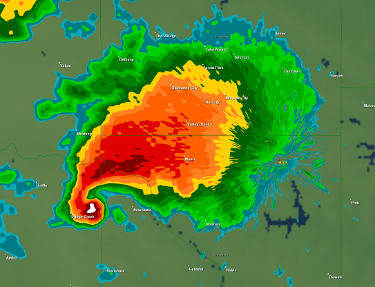
If you’ve lived in the Midwest long, you’re probably familiar with radar images of storms. The big blob of red and orange is heavy rainfall — which is probably what most people (including myself) look at on the weather station as storms are approaching. See how there’s nothing to the south? Again, that’s not coincidence.
This radar signature is called a hook echo, and is a fairly common appearance of strong thunderstorms. If you look closely, there’s a small white blob in the bottom left corner of the image, with a kind of swirl around it, leading back to the big blob to the northeast. That is a mesocyclone, a several miles wide area of rotation air within the thunderstorm. That the base of the mesocyclone is where wall clouds and tornadoes can form. Remember when I said earlier that wall clouds form in between the rainy downdraft side of the storm and the rain-free updraft side? That’s what’s happening here — it’s raining on the north half of the storm and there is a whole other half of the storm on the south side with no rain, so it doesn’t appear on the radar.
So why does this matter? When you’re watching the news or NOAA, or whatever source you get your severe weather updates, don’t get too distracted by the big blobs of colors. The real danger might be elsewhere.

Leave a comment